|
|
FROM A TWIG
TO A MIGHTY OAK: Part
3 The following is Copyright © 2016-2020 by Clayton
Barker, all rights reserved. It was published on the editorial page of The
Burford Times, June 16th, 2016, in Burford, Ontario, Canada.
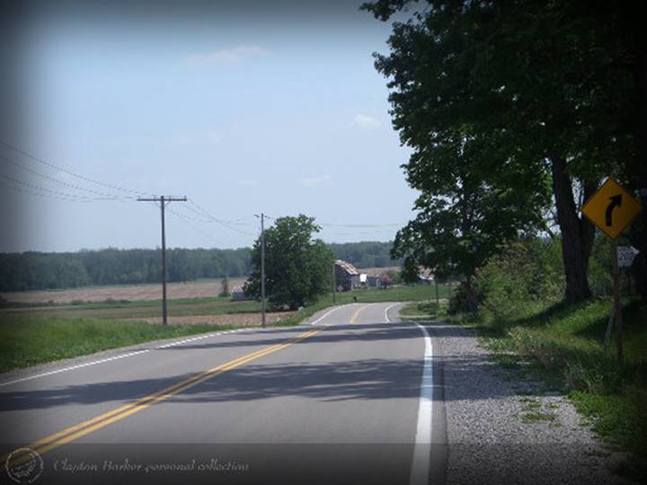
This is the Harley
Road looking south from the 8th concession road corner. The Harley
Road follows the top of the Norfolk Moraine. In the days of the early
settlers, this ridge was covered in a solid dark coniferous forest, referred
to by the early surveyors as a “pinery.” Photo by Clayton Barker For several thousands of years, the
lower half of Burford Township, which drains towards Lake Erie, was covered
by a meltwater sea, while the northern half, which flows to the present-day
Grand River, was a herb-dominated tundra. The tundra
became a lichen woodland where various plant and animal species were
introduced / re-introduced to what was barren glacial-tilled ground. Geologists have applied names to the
various stages of these inland freshwater seas or glacial lakes, such as
Maumee, Whittlesey, Warren and Iroquois, to keep them straight, however, they
cannot agree on the estimated duration of time these lakes had existed.
Radiocarbon dating is one of the ways in which they have been able to
determine how long ago these various stages had occurred. About 14,000 years ago, according to
some geologists, a pro-glacial lake named Lake Maumee, was formed and covered
the western half of the Ontario peninsula and parts of Michigan and Ohio. It
was the first of a series of glacial lakes that occupied the Lake Erie basin.
The term pro-glacial lake means that it formed directly along the ice margin
and the land to the south sloped toward the retreating ice lobes, trapping
the water between the ice and the higher ground. During the Maumee stage of
the formation of the Great lakes, of course, Burford and the rest of Ontario
was still under the ice. (Chapman & Putnam, 1984) About 1000 years later, the next body
of water to occupy the Lake Erie basin is referred to by geologists as “Lake
Whittlesey.” Whittlesey encompassed the entire Erie basin and a bit more
south into New York and Pennsylvania and all of the area which its
predecessor Maumee had covered in Michigan and Ohio, as well as half of
Southern Ontario. Whittlesey’s ancient shoreline can still be seen today in
areas of Ontario and particularly Brant County, where a meltwater river
entered Whittlesey. Lake Whittlesey is also a pro-glacial lake. However, only
about 20% of its shoreline coincided with the margin of an ice lobe: The
Huron lobe on the north shore (basically occupying the present Lake Huron
basin) and the Ontario ice lobe at the eastern shoreline (occupying the Lake
Ontario basin). (Wikipedia.com) During the duration of Whittlesey, a
portion of Southern Ontario and central Ontario was exposed which probably consisted
of a herb-dominated tundra. The countryside was
scarred by the movements of ice, and the accumulation of debris left during
the glacier’s retreat. Some large chunks of ice or ice burgs were left behind
and were mired in the debris and later gradually melted to become what we
call “kettle lakes.” There are at least four kettle lakes in Burford Township
including Crestwood Lake (formerly Cooley Pond on the 4th concession) and
Levey Lake (on the 2nd concession), one on the 10th concession and one on the
12th concession, between Maple Avenue and Bishopsgate Road. Some present-day rivers and major creek
drainage basins were in their early formation, such as the Thames, the Grand
River and Whiteman’s Creek. It is interesting to note that the Grand River only
went as far as the present-day Town of Paris, meanwhile, the present-day city
of Brantford was under about 60 metres of water. The Grand entered Whittlesey
just north of Paris where it had also created some deltas, which can still be
seen north of Highway No. 5 and east of East River Road. Whiteman’s Creek was actually a “raging”
river, which was over a kilometre in width near where it entered Whittlesey’s
shoreline, at what is now Mount Vernon. REFERENCES: For this series of columns,
information has been gleaned from the following: “The Physiographic Regions
of Southern Ontario, Third Edition,” (1984) by L.J. Chapman and D.F. Putnam;
wickipedia.com; “Historical Atlas of Canada,” by R. Cole Harris, editor and
illustrated by Geoffrey J. Matthews, cartographer. |
|
CLICK TOPICS BELOW |
|
|
|
|
|
|
|
|
|
|
|
|
|
|
|
|
|
|
|
|
|
|
|
|
|
|
|
|
|
|
|
|
|
|
|
|
|
|
|
|
|
|
|
|
|
|
|
|
|
|
|
|
|
|