|
|
BRANT - ONLY A
POLITICAL BOUNDARY: The following is Copyright © 1997-2020 by Clayton
Barker, all rights reserved. It was published on the editorial page of The
Burford Times, in October of 1997, in Burford, Ontario, Canada.
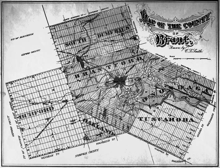
1875 Illustrated Historical Atlas of
the County of Brant, Ont. By Page & Smith. I wrote the following article back in
1997 to give an historical view on local government structure here in the
former Township of Burford. It was written at the time when nobody knew what
the new restructured Brant would consist of, and there was much talk about
the "One Big Brant" theory, which would have included an
amalgamation with the City of Brantford. The former Township of Burford had
originally consisted of about 24 communities: Burford (formerly Claremont),
Bishop's Gate [Note: not known as Bishopsgate all-one-word like people call
it today] Cain's Corner's, Falkland (formerly Woolverton's Mills), Etonia,
Princeton, Gobles, Creditville (formerly
Sheffield), Muir (formerly Trimble's Corner's), Cathcart (formerly Sydenham),
Victoria (formerly Rag Town), Salem, Harley (formerly Derby), Northfield
Centre (formerly Florencevale), Fairfield Plains,
Scotland (also known as Malcolm's Mills), Kelvin, Ranelagh, Mt. Zion (also
known as Wale's Corner's), Tansley, Woodbury (formerly Forces Corners), New
Durham, Hatchley (Hatchley Station), Norwich Gore. Most of these hamlets or settlements
no longer have much of a main street any more. In most cases there are no
store's or shops to difine what was their centre of
business. However, In the beginning, they all had a church and a school,
which was what brought the people together and gave them their community
identities. Even though the schools and churches
have all been amalgamated and most of them torn down, those families who
remain in these areas continue to identify themselves with the name of the
hamlet that had once thrived there, which has long disappeared. Along the
concession roads in the areas between each hamlet or settlement, you will
also note that most of the old century farms have also disappeared. On the
other hand, however, it is plain to see that there are many new single family residential homes and properties, which are
on the increase. They compensate for the missing farms and therefore indicate
that these rural areas are not always disappearing. In the last few weeks there has been
great confusion and uncertainty concerning the future of the County of Brant
and what will be its Municipal make up / structure. I think the residents of
the present Township of Burford owe their Township councillors a great deal
of credit for standing firm and holding their ground on the issue of County
restructuring. They have done well to not be swallowed up whole by the
illusion that the "One Big Brant" theory is so great! [Note: the
"One Big Brant theory included the City of Brantford]. Just look at it
this way - Just be glad you have an elected Township Council who can go to
bat for you and also give you the opportunity to voice your opinions! Going back 146 years ago when the
Township of Burford was shoved into a provisional (temporary) united County
of Brant with portions of Wentworth and Halton, nobody had a choice. Before
1851, all the lands within the present County of Brant except for Burford and
Oakland Townships were part of the original “Haldimand Grant" (Six
Nations of the Grand River) and were associated with Ancaster and Hamilton.
Burford and Oakland belonged to Oxford and were associated with Woodstock and
London. Forms of government, such as
one-tier, two-tier, three-tier, are one thing and physical boundaries, known
as geographic Townships, another. Townships have existed in Ontario for over
200 years but only as Surveyed grid systems to divvy up land into parcels of
individual or group ownership. Township Government on the other hand has only
been in existence in Ontario for a short period of time. Burford was
originally surveyed in 1793 as a physical "Township", but it wasn't
until after the passing of the Municipal Act of 1849 (abolishing single-tier
Districts and allowing the formation of Township and County Councils) that
Burford's Township council was formed on Jan. 21st.1850. In the years between
1792 and 1842 all the affairs of the province of Upper Canada (now Ontario)
was run by the provincial government and martial law presided over the
land...sound familiar? Maybe this is the direction our Provincial leaders are
leading us these days, with the potential mandatory mass fingerprinting of
all of the provinces' people and restructuring to reduce the number of
Municipalities in the province? Physical and cultural boundaries, to
the upper tier government, mean nothing. To them the province is a
two-dimensional map hanging on their wall and the history of the people who
live there began when these individuals were elected to parliament! The key
word here is "elected". We can un-elect them just the same! Regardless of the political /
judicial boundaries that, for one reason or another, change over the course
of time; there are well established cultural boundaries within the fabric of
the County of Brant and these will probably never change. Since Burford was
always situated at the western edge of what was classified as "The Indian
Lands" i.e. being physically segregated from the fast-growing industrial
steel towns east of the reserve (at the head of Lake Ontario), Burford
developed strong ties with Woodstock, which it shared a common heritage with.
In 1788, following the American
Revolution, the province (then known as Quebec) was divided into four
districts, which were very large, as the population of the then vast
wilderness was very low. Each of these districts had one representative in
the government, and all of the lands west of the Six Nations Reserve and
between Lake Huron and Erie and east of the St. Clair river was in the
District of Hesse. By 1792, the British province of Quebec was divided into
Upper and Lower Canada and the four districts remained, but were further divided
up into 19 counties - each county being represented at parliament by only one
member. However, the three counties of Norfolk, Oxford and Middlesex were
grouped together with only one representative for the group. The 19 counties that were designed by
parliament in 1792 were only outlines or blocks of smaller portions of the
province but did not have established county councils. Also, the district of
Hesse was renamed the "Western District" (which Burford belonged
to). As more and more settlers came into the province, the need for better
representation grew and in 1798 the province of Upper Canada underwent a
'restructuring' and an Act was passed to create 8 district governments to
oversee 23 Counties with 158 Townships. Again, County governments and Township
governments did not exist. Only one appointed representative looked after the
people of each district at parliament. Burford of course belonged to the
County of Oxford, located in the District of London (formerly the Western
District). I would like to point out, that the
Township of Oakland was originally surveyed as part of Townsend (in Norfolk)
and was known as "The Townsend Gore", but in 1800 was added to
Burford and also Oxford and was known as "The Burford Gore". It
wasn't until 1821 that the Burford Gore was given Township status and was
renamed Oakland - but remained with Oxford. Back then, politicians shuffled
District and County boundaries as they pleased and did not have to worry
about the opinion of the ratepayer. It is interesting to note that also in
the year 1821, the Townships of Nissouri and Zorra were added to the County of Oxford. By 1825 there were 11 districts in
the province and more change was on the horizon. In 1839 another Act of
parliament was passed which reduced the size of the districts and the
Township of Burford belonged to the District of Brock, which included: Nissouri, Zorra, Blenheim,
Blandford, Norwich, Dereham, Oakland, North Oxford, West Oxford, and East
Oxford. In 1849, with the passing of an Act
of Parliament, Known as the "Municipal
Act", districts were abolished and Township and County governments were
given the 'green light'. Burford Township Council was formed in 1850 and for
a year it was in the Oxford County structure. Then in 1851 another Act was
passed which called for the "restructuring of certain Counties for
Judicial, political or other reasons," and Burford was hacked away from
Oxford and shoved into a vat with portions of Halton and Wentworth. This strategic
manoeuvre, all of a sudden, overlapped the so-called "Indian Lands"
and soon there were no more "territorial barriers" along the road
between Ancaster and London. A County courthouse and Gaol was
constructed in what was then the Town of Brantford and on Jan. 24th, 1853 the
first meeting of the newly formed County of Brant was held and the
provisionally (temporary) united Counties of Halton-Wentworth-Brant was
dissolved. Now, in the year 1997, (almost 150 years later) someone is trying
to force a change that will put us back to a district situation, except this
time there are larger populations in the individual Townships and the city of
Brantford and Town of Paris. Someone is always trying to re-invent the wheel
and still others somehow find ways for history to repeat itself. In the 1830's & 40's the larger
districts were reduced and divided up into smaller Townships for better
representation to the people as the populations increased. In the "One
Big Brant" scenario, it would be the reverse; there would be one large
body with a handful of representatives - not necessarily originating from
your own particular geographic area, mind you. These newly elected
"Aldermen" would be in charge of a larger population - possibly too
large to handle. "Less" is not
"more" when it comes to representation. People need to know that
someone who shares their home turf is up there at the Council meetings
delivering first-hand, information and concerns, which require council's
attention or action. Let's not see history repeat itself like it did with the
rebellion of 1837 - which was caused by poor or insufficient representation. ------------------------------------------------------------------- DISCLAIMER The information contained on this
page represents the research findings and opinions of the author. The
material on this page reflects the author’s best judgement in light of the
information available at the time of compilation. Any use of this material
made by a third party, or reliance on, or decisions made based on it are the
responsibility of such third parties. The author accepts no responsibility
for damages, if any, suffered by any third party as a result of decisions
made or actions based on this work.
REFERENCES: My brain and everything that it has collected
over the past 58 years... -
Null - |
|
CLICK TOPICS BELOW |
|
|
|
|
|
|
|
|
|
|
|
|
|
|
|
|
|
|
|
|
|
|
|
|
|
|
|
|
|
|
|
|
|
|
|
|
|
|
|
|
|
|
|
|
|
|
|
|
|
|
|
|
|
|