|
|
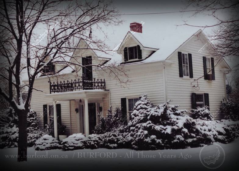
THE OLD MILES
PLACE, c1860
View of the Miles residence,
King Street West, Burford, Photo by Clayton barker, 1990 The Old Miles Place: PART 1 Copyright © 2018 to 2021 by Clayton Barker (Published in The Burford Advance, July 12th 2018) Many years ago, when I was a young lad attending
Maple Ave. Public School, in Burford, the students were given tours of
various businesses and interesting places around the village, like Judge’s
Apiary on Maple Avenue South, and Miles’ Greenhouse on King Street West. I
recall it may have been around Mother’s Day when we toured Miles Greenhouse,
as we were each given a small plant to give to our mothers. The late Roy Miles (Roy Wilbur Miles 1913-1996)
the owner of R. C. Miles & Son Florist and greenhouse, at the time, gave
us a tour and we were told the story of how Roy’s father (Robert Carter Miles
1872-1963), started his florist business with “cold frames” and how he
acquired tulip bulbs from Holland, etc. That was the first time I had met Roy,
and those tours of the various businesses here in the village were very
interesting to me, and the first opportunity I had to walk the streets of
Burford, since my brother and I were bussed in from the fourth concession
(Woodbury/Tansley). A few years later, my family moved into the
village of Burford and lived on Dufferin Street, which is in the same village
block as the former Miles Florist property, bounded by King Street West,
Dufferin Street, Jarvis Street and William Street (now Saint William Street).
I had a brand new 3-speed bicycle given to me for my tenth birthday and to
familiarize myself with my new bicycle (which was slightly too big for me)
and my new surroundings, I would ride around the block. For the first while,
however, I wasn’t allowed to venture off to anywhere beyond our block, so to
break up the monotony of just going around and around the block, I would
sometimes incorporate the Miles’ driveway into my ride too, since it linked
Dufferin Street to King Street in the middle of the block. Roy never minded me using his driveway, as long
as I was careful to watch for moving vehicles. Sometimes I would stop to chat
with him and his wife Kay while they sat on their back porch. Being the young
history buff that I was, I asked Roy if he knew how old his house was, so he
took me on a little tour and told me that he figured it would have been built
sometime before 1879, the year his grandparents (George and Mary Ann Miles)
came there. He also told me that he had tried to make the house look like a
much older house by adding dormer windows and porches to it and other
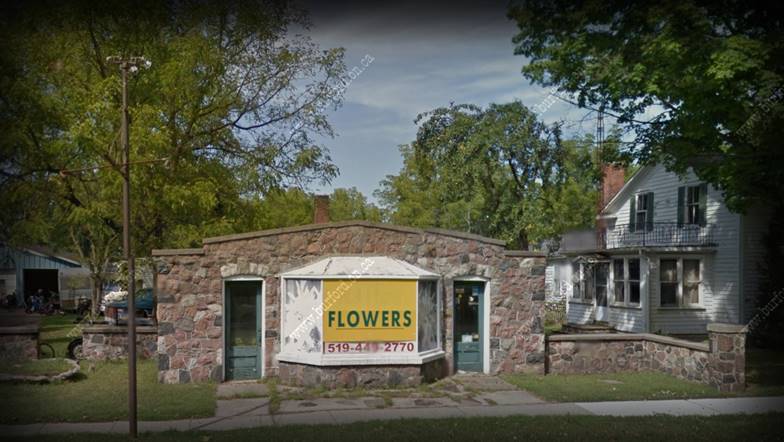
renovation work, in the 1940s. The little stone florist shop, near the front of
the property, was built in 1939 (removed recently and the stone incorporated
at bethel Church, near Paris) and according to Roy’s son David, who still
lives in the Burford area, the first greenhouse built on the property was the
large one behind the shop, and there was a tunnel that linked the shop and
greenhouse to the main house basement. The present (red) barn, on the east
side of the lot, was originally located directly behind the main house but
was moved to its present location in the late 1960s. There were other sheds
and storage garages and glass-houses on the lot over the years, some of which
were demolished in 2010, and the smaller house, which still exists, has now
been severed off into a separate lot. The oldest building on the property is
the main house (which was being renovated when I wrote this article). Interestingly, though Roy had tried to disguise
his house as perhaps an 18th century home in New England with modern
features, the strong Canadian colonial look with its die-hard symmetry and
front entrance, flanked by sidelights, typical of the first half of the 19th
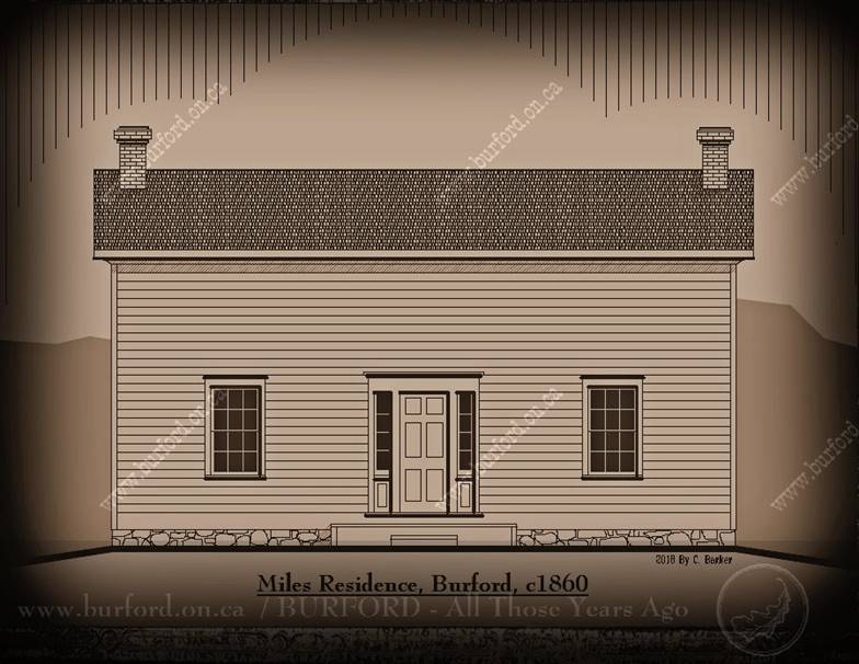
century, still comes through. According to a very old photo published in the
Burford Advance (1979) showing the house as it looked in the 1880s, it was a
plain and simple looking typical Regency period (1820-1860) home, built with
a Georgian influence. It was without shutters or porches in the beginning and
the front entrance had a 6-panel door. The lower windows were large-paned
double-hung windows in a 6-over-six muntin bar grid, while the upper windows,
on the gable-ends, were smaller and narrower, possibly in a 9-over-6 pattern,
a carry-over from the British “Window-Tax” era, pre-1851. Also, in the photo
you see the 6 members of the Miles family, including Roy’s father, and the
yards are all enclosed with beautiful white-painted picket fences. Some of
the gardening obviously took place actually in the front fenced yard, while
several acres of land, in the back lot, was utilized for market gardening.
The Mile’s little stone
flower shop, built about 1939. The Old Miles Place: PART 2 Copyright © 2018 to 2021 by Clayton Barker (Published in The Burford Advance, July 19th 2018) In order to take you back to the days when the
old Miles property was created, I have to go back to when Burford was being
called “Claremont.” It was 1852 and up until that time, development of the
village had been mostly rural and a bit scattered over a distance of about
three kilometres. The four corners of the village were established, however
not yet defined as the “main business core.” Many competing businesses, such
as hotels and general merchants, had their own little section of the main
street in spurts here and there, but not in any one particular core area.
Also, for the longest time, development was mostly at the west end, which was
the older part of the village. The Street Line: Back before 1852, there were large gaping empty
areas of fields or woods in-between developed areas along “Burford Street,”
(now King Street) particularly in the area where the Miles house was
eventually built. Along the road would have been continuous split rail or
stump fences. However, the fences in front of houses and public buildings
were usually either a picket or a solid board type to keep roaming livestock
out. Farmers herded their livestock up and down the roads, therefore it was
necessary to fence everything off. The laneway to the former Landon family farm of
the late 1790s was likely still visible in 1852, as it divided the property
right in the middle, at what later became the road allowance for a street
called “North Street,” which was changed to “William Street” in 1882 and it
is now called “Saint William Street.” (Note: Nathanial Landon was the original settler on lot 4,
concession 6). There was a 10-acre grassy pasture to
the west of this lane, which was the former “Village Green” or Military
parade ground, during the late 18th century and there was a 50-acre farm to
the east of this laneway, which had originally belonged to Cicero Madison
Ives before 1838. At the north end of the old Landon laneway, somewhere
between Burford Street and the creek, in what is now the subdivision we
1970’s Burfordites used to call “the Clark Survey”, would have been the old
log-constructed Landon farm buildings, although it is possible that by 1852
the original log house was replaced by a 1 1/2 storey frame house. Across the
road from the former Parade Ground, on the south side of Burford Street was
the fine farm and 2-storey home of Joseph Pickle (The late P.A. Sprowl
house). The front bricked section of which had just been built c1850/51. The Property: The township lot 4, concession 6, where the Miles
place is located, which also forms the north-west quadrant of the village, had
originally been settled, as I had mentioned, by Nathanial Landon, in 1797.
The Landon’s came from Sussex County, New Jersey and settled in Burford
Township when this area was yet a wilderness with only a handful of settlers.
Later, the Landon family moved to the 5th concession and what is now the
Bishopsgate Road and the old Landon property here was sold to another
Nathanial - Nathanial Ives, a miller and merchant from New Haven Connecticut.
Nathanial Ives built the first sawmill in the area in 1817, located on the
north-east 10-acre portion of the lot, near the Whiteman’s Creek. By 1832 and
prior to returning to the US, he may have also had a grist mill there as
well. Nathanial sold the south-east 50-acre quarter of his lot to his brother
Cicero Madison Ives, who established the first general store in the vicinity
of the present business core (near the present post office site) before 1820 [refer to my
article about the Sibbick’s Antiques building demolished about 2017]. Because of the animosity and political unrest
caused by the rebellion of 1837, things were hard for those enterprising
merchant Americans who settled here after the war of 1812. For instance, the
Ives family members, Cicero M. and his son Nathanial J. went bankrupt and
returned to the US to start over, in 1838, though Cicero had just signed up
with the local militia (R. C. Muir,1913). It is not clear whether the older Nathanial
Ives (brother to Cicero) also went bankrupt or not, as he is not listed in
the Chancery notice published in the Kingston Chronicle of 1841. While the
lands of the older Nathanial remained, the lands and premises of Cicero M.
and Nathanial J. and premises were handed over to the Bank of Upper Canada,
under the care of a well-known Family Compact-era character named Thomas
Gibbs Ridout. The property was auctioned off in October 1841 (Dictionary of
Canadian Biography). Speaking of the animosity and unrest caused by
the rebellion of 1837, even a fine Irish-born prominent government-appointed
public servant such as James Scott Howard of York was relieved of his duties
as postmaster of the newly formed city of Toronto and found himself awaiting
the outcome of his appeals to the government (to get his job back). Through
Thomas Gibbs Ridout, James Howard was able to pick up the former Landon /
Ives 190-acres of land from the Chancery sale and he moved here to be closer
to some relatives of his and to do a bit of thinking and farming (townofyork.com). James Scott Howard, the first of the Irish-born
characters in the Miles house story, was born in Bandon, County Cork,
Ireland, and came to Canada in 1819. He was wrongfully dismissed as Post Master,
in York (Toronto) by the government. It appears that Howard actually wasn’t
all half bad, just that the new Governor of the province didn’t like him.
Ironically, he came to Burford, which was considered to be a “Rebel’s Nest”
by the government. For a very short time, he lived on the lands formerly occupied
by Cicero M. and Nathanial J. Ives but the deed was not registered until
several years later. By that time, he had been appointed Treasurer of the
Home District and the United Counties of York and Peel and moved back to
York. Howard may have rented out his property to
relatives for a few years here in Burford (or perhaps members of the White family?) as he appears to own it from 1842 to 1848. However, in 1848
George Hazelton White, an Irish-born builder/developer and land speculator
also from York (Yorkville) purchased all of James Howard’s land holdings here
in Burford on spec. It was by way of
this transaction that Burford’s connection to Yorkville and to a group of
enterprising Irish settlers becomes most apparent. In 1852, George hired the Irish-born Provincial
Land Surveyor George P. Liddy to create an urban-style residential
subdivision to take up the entire front 20-acres of his land, which included
the former Militia Parade Ground and the former Landon laneway and the
remaining 170 acres was sold in 1853 to Elisha Stuart (Note: As a child,
Elisha had lived just outside of St. George at what we now call the Adelaide
Hunter-Hoodless Homestead. His father’s family were direct descendants of
King Alfred The Great). It is interesting to note that the
surveyor, George P. Liddy was born in 1806 in Belfield, Armagh Ireland and
had worked in England with the Department of The Ordinance and participated
in the survey of Great Britain and Ireland. He is also accredited with the
preparation of the map and survey of the then Village of Yorkville in 1851. Between 1853 and 1856 several of the 0.3-acre
urban residential lots were sold to a partner and fellow Yorkvillian Joshua
Courtney, born 1826, Derryadd, County Armagh, Ireland. It is not clear what
part Courtney had in this enterprise, however in the 1851 census of Yorkville
he is listed in the household of one of George White’s family members as a
“labourer” which can be equated to many occupations, including builder. Either Joshua Courtney or George White himself
could have been the builder of the Miles house and it is possible that the
Miles house could have been built as a “model home,” similar to what they do
today in modern subdivisions, as the house was constructed very close to the
street, in an urban manner. There were no other buildings along that stretch
for several hundred metres built that close to the street, except commercial
buildings. Prior to this, non-commercial buildings, such as single-family
homes, were built quite a-ways from the street in a rural manner.
Rendition showing
what the Miles place looked like when it was first constructed. (Cad drawing
by Clayton Barker 2018) The Old Miles Place: PART 3 Copyright © 2018 to 2021 by Clayton Barker (Published in The Burford Advance, July 26th 2018) Up until the year 1852, there were not too many
residential lots available to build on in the vicinity of the village of
Burford as it was mostly agricultural fields. George Hazelton White, of Yorkville, saw
this need and opportunity and set out to establish as many as 56 small
residential lots in a 20-acre subdivision prepared by the surveyor G. P.
Liddy. (Note: Some of Georges’
family had lived in the vicinity of the village of Burford prior and were
noted here in the 1851 Census). White ear-marked a few “building
lots” throughout his subdivision for himself too, so he could build a few
houses and commercial buildings on spec. It is possible that he wanted to
“kick-start” building activity and give the impression that his development
was well underway and not going to fall back into being agricultural fields
again. White may have also taken part in the construction of the Wesleyan
Methodist Church since it was also located in his subdivision (south-east
corner of Dufferin Street and Saint William Street), completed in 1858. The former Miles Florist property of the turn of
the 19th century was comprised of fourteen of White’s subdivision lots,
totalling approx. 4.2 acres including the former Burford Armoury property,
however, just prior to the Miles family coming to Burford, ten of these were
merged again to become farmland in 1862 when Francis Gowdy purchased them
from Joshua Courtney and merged them together with several other pieces of
land nearby, which was being farmed by him at the time. This is precisely
what White had feared would happen! Who knows, maybe the people of old
Burford did not think too highly of the urbanization of their quiet rural
farming community? Meanwhile, the property where the old Miles house is
located was a separate lot from the rest prior to becoming merged with the
larger lot, known as lot 13 of Block ‘C’ of the soon-to-be incorporated
“Village of Burford”. The Gowdy Family: Francis Gowdy (born 1818 County Armagh, Ireland)
and his wife Anna (Boyd) along with their children Wm. Francis and Margaret
are listed in the 1871 Canadian Census as living in the village of Burford in
a 1 ½ storey frame house with servants John Courtney and Jane Strobridge
(Note: I have not found any connection between this John Courtney and Joshua
Courtney who I’ve mentioned before and the Strobridge name is also connected
to other land transactions by Gowdy in the same area). In the voter’s list of 1874, Francis is listed as
a farmer and his property is a portion of part lot 4, concession 6, which the
Miles property forms a part of. The Gowdy family at first, resided in a
different house, or small “farm” perhaps located nearby (possibly near or on the
present site of #142 King Street West and #18 Dufferin Street. At that time,
the Gowdy property included several acres which encompassed half of the
present village block west of what was called North Street (now Saint William
Street) and also other lands east and north there. Francis Gowdy was the
Great Grandfather of the late Max Gowdy, father of Brian. In 1879, Francis Gowdy sold the larger portion of
the subject lands to George Miles, a farmer from the Fairfield area, and
Francis and his family moved to Fairfield Plains. The Miles Family: George Miles was born about 1819 in Donaghmore,
Tyrone, Ireland, the sixth child of ten children of John Miles and Maria
(Baker). John and Maria came to Canada sometime before 1845 and settled on a
farm east of New Durham. George and his first wife Julia Catherine Lampman
were married in 1845 and lived on a fifty-acre farm north-east of Fairfield
(part Lot 2, Con. 9) and were listed in the 1851 census as living in a 1 ½
storey log constructed house. George and Julia had five children, then Julia
died in 1863. George was remarried in 1871 to Mary Ann Carter, of Clinton
Ontario and they had about 6 children (some may have died in infancy) and in
1879 moved to the village of Burford, as mentioned. Though George had about
eleven offspring total, between his two wives, he
and Mary moved to Burford with only four of their children being listed as
living with them – the others were grown up and married off and living in
places like Windham Township and Waterford. The Builder: Though the date of construction and the name of
the builder of the Miles house was not recorded, it is possible that either
Joshua Courtney or George White may have built it sometime between 1853 and
1860 or perhaps even John Walker Dickie, son of Hiram Dickie (brother of
Alexander, of Dickie’s Corner’s fame) may have built it sometime between 1857
and about 1865. Dickie owned the smaller lot where the old Miles house sits,
between 1857 and 1871. The Miles house represents an c1860’s part of
Burford’s architectural heritage. --------------------------------------------------------------------- DISCLAIMER: The
information contained on this page represents the research findings and
opinions of the author. The material on this page reflects the author’s best
judgement in light of the information available at the time of compilation.
Any use of this material made by a third party, or reliance on, or decisions
made based on it are the responsibility of such third parties. The author
accepts no responsibility for damages, if any, suffered by any third party as
a result of decisions made or actions based on this work. |
|
CLICK TOPICS BELOW |
|
|
|
|
|
|
|
|
LINKS To Check Out |
|
|
|
|
|
|
|
|
|
|
|
|
|
|
The Various Villages of Burford |
|
|
|
|
|
|
|
|
|
|
|
|
|
|
|
|
|
|
|
|
|
|
|
|
|
|
|
|
|
|
|
|
|
|
|
|
|
|
|
|
|
|
|
|
|
|
|
|
|
|
|
|
|
|
|
|
|
|
|
|
|
|
|