|
|
VARIOUS VILLAGES
OF BURFORD: Part
3
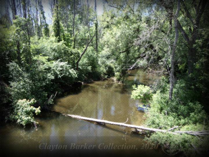
This is a view of a
portion of the Whiteman’s Creek that still remains from the days of the early
settlers, located at the East Quarter Townline North. (Photo by Clayton
Barker 2020) The Various
Villages of Burford: Copyright ©
2018-2020 by Clayton J. Barker Published in the April 26th 2018 issue
of The Burford Advance. People always ask me why Burford is
located where it is or why it is shaped the way it is, and the answer is much
more complicated than what they would expect. But the short answer is that
Burford is the product of several attempts being made by mostly American
entrepreneurs and merchant businessmen, at various times, to establish their
commercial presence along the stretch of road that followed a creek where
they attempted to create the focal point for a settlement. The Village of Burford sprang up where
it did because the main inland trail, between Niagara and Detroit, came close
to the Whiteman’s Creek at this location. All the necessities for a village
seemed to be readily available near this place. Plus, it helped that the land
in this area was only sparsely covered with trees and the soil easier to
plough, which gave our early settlers a head-start. It is possible too that
many of the large open areas along the creek were here due to the native
peoples inhabiting the area for thousands of years and building their huge
wooden walled villages and longhouses and creating their own fields. There was at least a half a dozen or
more waves or movements in the evolution of the Euro-American version of the
village of Burford, between 1793 and 1893 that created the settlement pattern
here. At one time there were six clusters or micro centres of commerce spread
out along the 2.5 kilometres between what is now the Harley Road and Maple
Avenue. It was as if each merchant settler wanted their own “elbow-room”, or
perhaps they had hopes that their location would become the absolute focal
point for a new village. But just like in the design of a strip
mall, you need to have at least two anchor tenants – one at each end, or else
eventually parts of the mall in the middle will die out because of lack of
exposure to potential customers. Since Burford was part of Oxford County at
first, most of the travelling community was coming and going from what is now
Woodstock, which is west of here. Furthermore, since settlements tended to
grow towards the direction that people were travelling, naturally, Burford
grew west of the location from which it was initially founded. Later on,
after 1852 when Burford was “put” in with the newly formed County of Brant
(i.e. hacked away from Oxford...) the judicial and electoral seat and the
main centre of commerce was located at what is now the City of Brantford,
which pulled things eastward from where it was. It is unclear as to why the founder of
Burford Township, Abraham Dayton, settled where he did along the main trail
or why he and his family did not just settle at an area closer to the 5th and
6th concession. It would have brought them closer to where Abraham had
planned to construct a mill (or mills). Instead, Dayton settled west of what
is now the present village of Burford, and not far from the 7th concession
road, which was more central, in the year 1793. It was also more convenient
for access to the main road (trail) where he would be visible and not have to
construct an access road for 4 or 5 kilometres to connect to the rest of the
world. There wasn’t much time before winter would be upon them and they had
to build a house, barn and set up fields. Remember, that the Dayton’s were
the only family here for that first winter, and there were no neighbours to
pull together for help, although they did get a lot of assistance from the
Six Nations people, in the adjacent “Haldimand Tract” (Six Nations of the
Grand River Territory). Abraham and wife, Abigail, were later
followed into Upper Canada by their daughter Abiah and son-in-law Benajah
Mallory in 1794. By 1797 Dayton had brought into the settlement 27 families
in total before he died and he was also responsible for the location of what
I call “Phase 1” of the evolution of the village of Burford. Abraham Dayton was originally the
appropriator for the settlement of “Burford” (Burford Township) and had been
granted the entire Township to establish a 29,000 hectare (112 square miles)
“New Jerusalem” for the religious group of which he was affiliated, from the
State of New York. However, when Governor John Graves Simcoe handed the land
patent to Dayton, he had mistaken Dayton’s religious group for Quakers.
However, after having come this far, into the wilds of Upper Canada, and
feeling free to do as he pleased, Abraham and Abigail decided to break away
from the group, who were indeed a cult. They decided not to return to the
states. Because of the mix-up about the Quakers
etc., Dayton had lost the majority of the Township land he was originally
granted but he and his family were allowed to keep several two-hundred-acre
lots for their own use, which included a property that came complete with a
“mill-seat” (a place where a water-powered mill, dam and pond could easily be
built utilising elevation of land). The latter was located in the 5th
concession at Whiteman’s Creek north-east of the present village. (Note:
this is not the site of Bechtol’s
Mill which was located about 500 ft east of here and later owned by the
Whitehead family). Everything would have worked out fine,
but shortly after Abraham came to Burford, he was injured, and he lay
bed-ridden for two years and died in March 1797. He was not able to commence
work on any such mill. Not long
before he died, the government noticed that his son-in-law Benajah had
settled on one of the government’s Crown Reserves, so they sent a surveyor to
document the condition of all of the lands held by the Dayton and Mallory
family. The surveyor assessed all the lands including the mill-seat site
property, and instead of booting Mallory off of the Crown Reserve lot,
decided to trade the mill-seat property for the reserve lot. The surveyor
recorded that the property where the mill was to be erected had not been
“improved” but was covered with “fine timber untouched by the blade of an
axe.” If Dayton had have succeeded in building
a mill at his intended site, the road configuration and settlement pattern
for what is now Burford would have been so much different than it is today.
Quite possibly, the 6th concession road, between Bishop’s Gate (known as
Bishopsgate today) Road and the East Quarter Townline, would have become the
main street of what is now Burford and, who knows, perhaps the 6th concession
would have become a section of 53 highway all the way to Cathcart, etc... PART 4 - Not available yet |
|
CLICK TOPICS BELOW |
|
|
|
|
|
|
|
|
|
|
|
|
|
|
|
|
|
|
|
|
Part 4 – not available yet |
|
|
|
|
|
|
|
|
|
|
|
|
|
|
|
|
|
|
|
|
|
|
|
|
|
|
|
|
|
|
|
|
|
|
|
|