|
|
VIDEO
#1: The Old Stage Road – Along the Detroit Trail The following is Copyright © 2020 by Clayton
Barker, all rights reserved. These pages are the script/narration which I had
prepared for my new video series, BURFORD – All Those Years Ago. To watch the
videos please follow the hotlinks below, either to my YouTube channel or to
each individual video – Thanks!
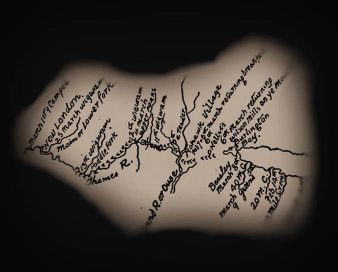
Excerpt of map
which Elizabeth Simcoe had copied,1793 Published in
"The Diary of Mrs. Simcoe" by John Ross
Robertson, William Briggs,
1911 University of
Toronto Library My YouTube Channel is as follows: https://www.youtube.com/channel/UCWGbWGspBawZG9K-x5NmT4Q Here is the hotlink to video#1: PART1 https://www.youtube.com/watch?v=Vgc8scwpkTI&t=45s Here is the hotlink to Video#1: PART 2 https://www.youtube.com/watch?v=Uo1E6c3q6Z4&t=54s NOTE: Links to other videos can be found off to
the left here, thanks. INTRODUCTION: Welcome to BURFORD - All Those Years
Ago, and my first virtual historical tour. In the past, I have taken small
groups along the streets of my hometown of Burford and had shared what
stories and information I have accumulated over the years to small groups of
about 6 or 10 tour-goers. Pausing at each place along the way, I have told
the history, as I know it, and I have highlighted the importance of each
place, its architecture, and the significance of the people who had been part
of its story. However, because of the issues and complications of organizing
assemblies of people, these days, due to Covid-19, I decided to take my
normal live historical tours, to the video screen. In this first video, we will be
looking at one of Ontario's oldest, most trod, interior roads, which
originated as an ancient trackway or foot path. It was referred to in the
1700's as the "Detroit Path" or "Detroit Road" or
sometimes the "Detroit Trail." This footpath became an important
link or portage route between Niagara and Detroit. Parts of this route still
remain as a winding gravel or paved road, though its importance has
diminished somewhat. We will only be looking at that
portion which passes through the counties of Oxford and Brant. The section we
will be looking at became known as "The Old Stage Road" during the
mid-19th century and the days of the stagecoach. The section of this road
which continued westward along the Thames River was sometimes referred to as
the "Thames River Road." Some sections of this stage-coach route,
near or beyond London were sometimes referred to as "The Longwood’s
Trail" or the "Hamilton Road." So, get your comfortable footwear on,
and hat too, if you like, and please, if you are in the company of others,
who you do not live with, mind the social distancing protocols and
restrictions. Enjoy the tour THE OLD STAGE ROAD - ALONG THE DETROIT TRAIL, PART 1 In pre-historic times, this footpath
provided a link between hunting grounds and areas of trade for the indigenous
people who first called this place “home.” In the 16 and 1700’s it became a
crucial inland trade route for trappers between the forts and trading posts
located at Niagara and Detroit, and passed through what is now the geographic
Township of Burford. Sometime between the late 1600s and the late 1700s
however, this pathway was referred to as the “Detroit Path” or “Detroit Road”
or “Detroit Trail” - I prefer to just refer to it as the “Detroit Trail.” The Detroit Trail: was the only thing remotely
representing an interior road, connecting the settlements and fortifications
at Niagara and those at Detroit, and it extended a distance of about 402 km
(or roughly 250 miles). It was used
extensively by French trappers and Missionaries as a way to avoid the British
ships that patrolled Lake Erie. When John Graves Simcoe travelled through
this area in company with his expeditionary party of about two dozen men, in
the winter of 1793, they went by way of the Detroit Trail (D. W. Smith,
Archives of Ontario, Map 1792 - 1795).
Simcoe was the first Lieutenant Governor of the British Province of
Upper Canada and he had great plans and schemes in mind to transform the then
Upper Canadian wilderness into yet another “New England.” One of Simcoe’s greatest schemes was
to build a military road basically in a straight line from the head of
Burlington Bay westward to the site of his proposed capital, which he wanted
to be called “London.” Up until this
time the governor had only seen renditions of maps which had been prepared by
his surveyors prior to his arrival in Upper Canada and he hadn’t yet stepped
foot in this part of Ontario. On his map, however, his so-called capital of
London was yet just a speculative dot on a not-yet fully explored the
westward-flowing river, which he named the Thames, which the indigenous
people had referred to as the “Antler River.” The Mohawk leader Joseph Brant summed
up Governor Simcoe’s years here in Canada by saying “He had done a great deal
for this province – he has changed the name of every place in it” (Dawe,
1980). Previous to Simcoe’s arrival, however, the French had named this river
“La Tranche.” The military road he designed to connect the head of Lake
Ontario to his proposed capital of London he was named “Dundas Street.” He called them “Streets” because ancient
Roman roads were always referred to as “Streets” (Breithaupt, O. H. S.,
1924). In some ways, the British in the Upper-Canadian wilderness were not
unlike the Romans trying to civilize, conquer and assimilate the ancient
tribes of the British Isles and Europe. Dundas Street is a completely
different route from the Detroit Trail, though they are somewhat parallel and
lead to a common destination. Note: Dundas Street is basically
Highway #2 and also “Governor’s Road.” As I had mentioned earlier, Governor
Simcoe travelled through this area along the Detroit trail in the winter of
1793. He was travelling in company with an expeditionary entourage which
included Government officials, soldiers, surveyors, indigenous guides,
servants and a Newfoundlander dog named “Jack Snap.” The governor set out
from what was being called Newark (now called Niagara-on-the-lake) on
February 4th and followed the Detroit Trail arriving in Detroit on February
18th, which took about 14 days. The return trip to Niagara they left Detroit
on February 23rd and arrived back at Niagara on March 10th, a total of 15
days. Though they made better time on their return trip and should have
returned much earlier, they had lingered at some areas longer and stopped
more frequently along Lake Ontario at various settlements. A very prominent leader of the Mohawk
people “Thayendanegea,” a. k. a, Captain Joseph Brant along with several of
his men, accompanied the Governor’s entourage as guides. He was known as a
“Mohawk Chief” but was not a hereditary chief. Other members of the “Simcoe
Party” were individuals who went on to play significant roles in the
“Euro-American” development of Upper Canada: • Thomas Talbot, who was the
Governor’s private secretary, founded the community of Port Talbot, Ontario.
He was responsible for enticing 50,000 people to settle in the Thames River
area. He fought during the American Revolution, the Napoleonic war in Europe
then later commanded the 1st Middlesex Militia and held the position of
supervisor of all the militia regiments in the London District. Talbotville,
Ontario, the city of St. Thomas, Ontario, were named after him (Wikipedia). • Augustus Jones was a deputy
surveyor, and United Empire Loyalist. He was the surveyor that not only laid
out the Governor’s Dundas Street, but he also completed the initial surveyed
outline of Burford Township. • Lieut. James Givins, who was the
Superintendent of the Indian Department. He had fought during both the
American Revolution and the war of 1812. In 1820 Givins was promoted to
Colonel of the 3rd Battalion of York Militia, then Colonel of the 1st
Battalion of West York in 1821 (Wikipedia). • Major Edward Baker Littlehales,
Major of Brigade, was afterwards Sir E. B. Littlehales, and for some time
Secretary at War for Ireland. He was the first cousin once removed to Peter
William Baker, son of William Baker, Baronet of Ranston, in Devon, England.
Lieutenant-general Sir Edward Baker was given the title 1st Baronet Baker of
Ranston, Dorset. Sir Edward took the surname Baker as a condition of his
inheritance in 1817 (Wikipedia).
Major Littlehales kept a diary of the journey and although the main
features and rivers were quite accurately described and placed on a timeline,
he had only jotted down simple notations then when he was back home, he wrote
up the diary (thecanadianencyclopedia.ca). • David W. Smith (sometimes “Smyth”),
Deputy Surveyor General. He was also a member of the House of Assembly. In
1802, he returned to England and, in 1804, resigned from his appointments in
Upper Canada. He began a second career as property manager for the Duke of
Northumberland. Sir David W. Smith was made a baronet in 1821 (Wikipedia).
Smith also kept a journal of the trip, except his was more detailed
and he wrote it while on the trip and didn’t transcribe it later (D. W. Smith
/ Lewis, O.H.S.,1952).
------------------------------------------------------------------- DISCLAIMER The information contained on this
page represents the research findings and opinions of the author. The material
on this page reflects the author’s best judgement in light of the information
available at the time of compilation. Any use of this material made by a
third party, or reliance on, or decisions made based on it is the
responsibility of such third parties. The author accepts no responsibility
for damages, if any, suffered by any third party as a result of decisions
made or actions based on this work.
-
Please click here to go to PART 2 - |
|
CLICK TOPICS BELOW |
|
|
|
|
|
|
|
|
|
|
|
|
|
|
|
|
|
|
|
|
|
|
|
|
|
|
|
|
|
|
|
|
|
|
|
|
|
|
|
|
|
|
|
|
|
|
|
|
|
|
|
|
|
|