|
|
THE NAMING OF WHITEMAN'S CREEK |
|
CLICK TOPICS BELOW |
|
|
|
|
|
|
|
|
|
|
|
|
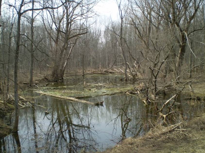
An
abandoned main branch of the original Whiteman’s Creek. When grist milling
operations began in the mid-1800’ in the Burford area the meanders of the
original creek were cut off and the creek straightened to speed the flow of
water to the mills. This original portion is the portion Governor Simcoe
would have seen during his trip here in 1793. Photo
by C. Barker, 2008 The
Various Villages of Burford, Part 1: Copyright © 2017-2020 by Clayton Barker (Published June 1st, 2017 in The
Burford Times) Starting with the
creek At
the end of what some people refer to as the “Ice Age,” A large river was
created which flowed west to east, cutting its way through newly-formed
moraines and sand plains and emptying its waters into a glacial lake, or
freshwater sea, east of what is now Bishopsgate. As the volume of water
lowered, it became a smaller river that meandered within the larger channel
that it had originally cut. Because the material it was cutting through was,
by the most part sand and gravel, it quickly chewed away at the sides of its
original basin and created a much wider basin, which can still be seen today
just north of the village of Burford where it measures over 2.5 km, at its
widest point. This process took a very long time, and
archaeological evidence shows that the creek, or river as it may have been,
was still very powerful and with wide meanders as late as about 5000 years
ago, when it cut through a very high bank (over 15m high) and the top portion
of a large archaic encampment was removed. By this time, the watercourse no
longer emptied into a glacial lake, but emptied into another newly-formed
river, which is now the Grand River. The Whiteman’s Creek watershed, which includes Horner and Kenney creeks, drains
portions of western Brant County and eastern Oxford County into the Grand
River, which is about 8 km east of Burford. It was originally referred to as a “Salt
Lick Creek,” especially near the area later known as “Victoria” (Rag Town)
where the Kenny (Kinny) Creek and Horner Creek come together, near the 6th
concession road. It looked like a “salt lick” to the early surveyor’s
(Augustus Jones in 1793 and John Stegmann in 1798) because the ground was
very wet and trampled looking there. At real salt lick’s, animals come to
lick the minerals from the soil. At the area near Kenny Creek, east of the
present-day Cathcart, the creek channel is not defined, and the vegetation
consists of mainly swampy grasses and very few trees. Later on it was
referred to as “Brant’s Creek” and then “Burford Creek.” It wasn’t until Victorian times that it
was actually referred to as “Whiteman’s Creek...” The
Various Villages of Burford, Part 2: Copyright © 2017-2020 by Clayton Barker (Published June 15th,2017 in The
Burford Times) The Village of Burford basically sprang up where it did because of its
close proximity to Whiteman’s Creek, and also because the main inland trail
between Niagara and Detroit, known in the 1790’s as the “Detroit Trail,” came
close to the Whiteman’s Creek near this location. All the necessities for a village
seemed to be readily available near this place, from an early settler’s
standpoint. The solid pine forest to the west, and a mixed deciduous forest
of walnut, hickory, ash, elm, maple, oak and beach that flanked the creek
drainage basin, would supply the settlement with all the timber needed for
buildings. The early settlers also took note of such things as bog iron for
iron production and blacksmithing, and clay deposits for potential brick
manufacture and tableware. There are several stories
of how the creek got its name, which all appear to have stemmed from one
story. The basic story is that the first “white” man (Caucasian) to settle in
this area, settled at the mouth of the creek, sometime in the late 1700’s.
Some variations of this say that his name was “Whitman” and that he drowned
in the creek. The
story, as told to me by the late Joyce Smoke, is that a white boy, who had
been adopted by a Seneca family (the family of Mary Jamieson) was raised by
the Seneca’s and continued to live at the junction of the creek and the Grand
River (now Five Oaks) where the Jamieson’s and other American Revolution
refugee families had settled. They had come up from the Susquehanna River in
the U.S. However, by the 1840’s most
of the native peoples had moved either onto the reserve (Six Nations of The
Grand River), or returned to the U.S. as did Mary Jamieson and some of her
family. Still others, remained as squatters near the junction of the Grand
River and Whiteman’s Creek. Mary Jamieson (or Jamison as it is sometimes spelled) was born aboard
a ship from England, her family was Scotch / Irish and settled in Eastern
United States, New York State. She survived a fierce attack on her family
home; a savage massacre perpetrated by the French and their Native allies
during the French-Indian War. She was taken into the Seneca tribe and adopted
and later married and spoke fluent Seneca. She had many children of which
some were from a Cayuga father. One of her sons was Thomas Jamieson. The
children traditionally took their mothers name back then. One time Thomas,
during his travels along the Susquehanna and Ohio Rivers (prior to the
American Revolution, in the U.S.) came across a boy who was playing beside
the river and Thomas became concerned for the boy’s safety. The boy was
fair-haired with blue eyes, like Thomas’s mother, so he felt in order to
protect the child from potentially drowning in the river, he’d take the boy
with him back home to his mother. He was given a Seneca name and raised by Mary
and her family. His Seneca name was
De-ha-na-ge-reh-gwenk though he also had an English surname of Hill. It was
told to me by descendants of Mary Jamieson that he got into a scrap with a
neighbour and was drowned in the creek. During his lifetime, he had gained
the nick-name of “Whiteman” in the settlement, due to his Caucasian features
and later on, he was even referred to as “Old Whiteman.” Therefore, it is
believed that he would be quite elderly at the time of his demise. According to the survey
notes by Pioneer surveyor Lewis Burwell in the 1820’s and 30’s along the
Grand River, he noted the location of “Old Whiteman’s old home,” which was on
land later known as “Strathmore Farm” which was the Griffin family estate in
the middle 19th century [Tremaine’s Map of The County of Brant, 1858]. In the 1840’s the majority
of Six Nations people were sent to the reservation and these settlements
along the creeks and rivers were no more. De-ha-na-ge-reh-gwenk’s descendants
did likewise. In the 1883 Warner and Beers History of Brant County his son
Abraham Hill is mentioned along with other relatives who were “born at
Whiteman’s Creek” but were living on the reserve during the late 1800’s.
Abraham Hill was born at Whiteman’s Creek in 1805 and married Mary Longfish
and had 5 children including Josiah (married Nancy Hill) and Richard. Some
others mentioned in the same book as having been born at the settlement at
the Whiteman’s Creek were James Jamieson and his sons James and David. It is also said that
Catherine Hill lived on this property as late as the early 20th century while
it was owned by the Pottruff family. There is now a plaque to recognize the
Hill’s and Jamieson’s having been a part of the history of this place, which
was erected 2008, near to this site. As well as the Seneca and
Cayuga settlement that were at the mouth of the Whiteman’s Creek, there were
several other satellite villages or encampments, along the Grand River, as
noted by the early Land Surveyor Augustus Jones c1791, and also further up
the Whiteman’s Creek in the early 1790’s. This was prior to Governor John
Graves Simcoe’s tour through Upper Canada in the winter of 1793 and prior to
the arrival of our founding settlers, Abraham Dayton and Benajah Mallory in
1793/94. It is said that one such encampment was located near what is now
App’s Mill, and another near what is now the Art Cadman Lion’s Park, north of
the village of Burford. These were perhaps temporary encampments for hunting
and fishing. The story goes that Thomas Jamieson, Mary’s son, would plant
apple trees from seeds from the apple trees of Thomas’s birthplace, in the
United States, at the various locations where his family stayed. It’s interesting to note
that my Great, Great Grandfather’s sister Annie Givens, came to Canada from
Berwick-on-Tweed, Scotland, about 1865. She worked as a housekeeper for a man
named James Miller who owned much of the land around Five-oaks. His first
wife had died however, later he married Annie and had a son George. He built
a very large house overlooking the creek adjacent to what’s now Five Oaks. It
was to be Annie’s “dream home.” Later it also became part of the Pottruff
estate and recently has been demolished. It seems that I became interested in
the stories Joyce told and the area of Five Oaks and App’s Mill because many
of my ancestors were connected to this area too. |
|
|
|
|
|
|
|
|
|
|
|
|
|
|
|
|
|
|
|
|
|
|
|
|
|
|
|
|
|
|
|
|
|
|
|
|
|
|
|
|
|
|
|
|
|
|
|
|
|
|
|
|
|
|
|
|
|
|
|